Since the completion of a three-year dredging project along the inner harbor of the Providence River in 2005 – mostly in the area north of Fields Point and south of the Fox Point Hurricane Barrier – industrial traffic has increased to the businesses along Allens Avenue, according to industry and state observers.
“When you have a narrow channel like [before the dredging], you start limiting the ability of a full-size ship to bring in large parcels of product,” said Capt. Howard McVay, who became president of the Northeast Marine Pilots about five years ago. His company supplies the state-licensed pilots that by law are required to guide foreign ships into ports. “Now we’re seeing bigger ships, loaded deeper, making it much more economically viable. And the amount of deep-water ships and products has increased significantly.”
His organization – one of the project’s largest supporters, along with U.S. Sen. Jack Reed – is also a founding member of the Providence Working Waterfront Alliance, a pro-industry group that formed during 2007 to fight zoning changes along the Allens Avenue industrial corridor.
R.I. Coastal Resources Management Council’s Dredging Coordinator Dan Goulet said the state contributed about $10.5 million to the more than $60 million project. And he said he’s seen evidence of a return on that investment. The deeper channel has been attracting new business, including Motiva Enterprises LLC in ProvPort.
“I see a whole lot more ships, which is great,” Goulet said, adding that at least one East Providence waterfront industry, Wilkes-Barre Pier, is planning a dredging project because “now they can bring larger ships, during all tides, up into the harbor. So the opportunity that this project has opened up for the state is enormous and the economic benefits, and not just for Providence, have high potential.”
The dredged channel, which in total runs from Sandy Point on Prudence Island to the Fox Point Hurricane Barrier, is at least 600-feet wide and is supposed to be at least 40-feet deep during low tide, McVay said. But during the years since the last dredging – it was deepened to 40 feet about 30 years ago, Goulet said – much of the bottom silt had edged into the shoulders, leaving a thin channel that was only about 38 feet deep.
So the Army Corps of Engineers went to work on the more than $60 million project. Last week they released the digital version of a report, the “Providence River and Harbor Maintenance Dredging Project Synthesis Report,” that says the predictive modeling for the dredging project was very close to the actual results.
Since the project’s completion in 2005, the Corps has been monitoring the area, said U.S. Army Corps of Engineers Program Manager Thomas Fredette, who’s based in the New England District office.
About 3.8 million cubic yards of sediment was removed from the bottom of the river, and about a third of that – 1.2 million cubic yards – was “unsuitable for unconfined open-water disposal,” according to the report.
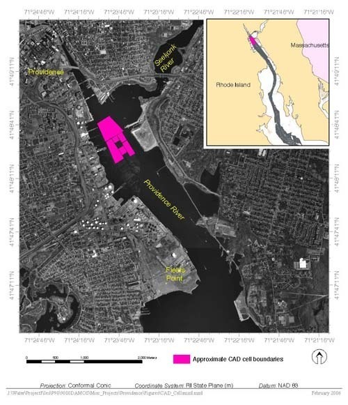
So that unsuitable material – mostly contaminated long ago by waterfront industries – was put in “CAD cells,” which are “confined aquatic disposal” holes dug deep into the riverbed. And, according to the report, monitoring of the water above the cells and farther south show that those cells kept the contaminated soil from moving downstream. •