Twenty years ago, the solution to congestion was simple: build more roads.
Today Rhode Island has little space for new roads, officials worry about their environmental impact and no one has money to pay for them. So transportation officials are increasingly turning to technology in an effort to squeeze capacity from the state’s roadways.
In the coming weeks, the R.I. Department of Transportation plans to activate electronic signs over the state’s highways with messages showing travel time estimates between locations. Next year, the R.I. Public Transit Authority expects to deploy technology that under certain traffic conditions will give preferential green lights to buses. And in 2013, the agency plans to track buses and provide arrival-time estimates at major bus stops.
Meanwhile DOT officials are studying linking traffic signals and automatically adjusting them depending on traffic flow within the wider area.
“The technology is proliferating,” said Robert Rocchio, managing engineer of DOT’s traffic-design section.
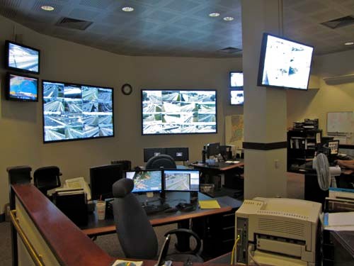
The DOT took its first major leap into integrating technology with roadways about 15 years ago with the deployment of video cameras along highways. Today, the agency counts more than 100 cameras that stream video back to a central traffic-management center and a public website.
The agency has also added electronic signs, built a network of sensors that track congestion and erected 11 antennas that broadcast traffic incidents over WPKL-AM 1630. The agency’s website also lists incidents and provides a map showing congestion.
The emphasis on technology over costly, new roads is occurring nationwide, said Lacy Love, the associate program director for operations for the American Association of State Highway and Transportation Officials. The adoption of technology has only gained steam as states face constricting budgets and struggle to maintain even existing infrastructure.
Private companies are also jumping into the fray. NAVTEQ Corp. holds an agreement with DOT to install traffic speed sensors along state highways in return for sharing the data at no cost with the agency. The data feeds into an array of applications, from online maps to navigation systems in vehicles.
Data will also play an important role in an effort by RIPTA to implement rapid bus service between Providence and Pawtucket. About 60 traffic lights fall along the route and each red one keeps a bus idling, wasting time and fuel.
So RIPTA is working with the DOT on a system that will let buses and traffic lights communicate. A bus running late and looking to make up lost time will request a green light from an upcoming light. DOT computers will analyze the surrounding traffic and decide whether to provide the bus a green light.
Amy Pettine, a special projects manager at RIPTA, said the system promises to increase the efficiency of bus routes. With a more efficient system, the agency can increase the frequency of buses without increasing the number of physical buses on the road. Or the cash-strapped agency could maintain the existing level of service with fewer buses and drivers on the road.
Across the system, RIPTA plans to outfit its entire fleet with transponders that will allow dispatch to track bus positions in real time. The agency can harvest that data to analyze its current efficiency, dispatch buses as need be and provide real-time arrival estimates at major bus stops and online.
The system, expected to cost about $9 million, is being paid for with federal dollars.
The ability of data to drive cost savings is appealing to transit officials across government levels. In Cranston, the city purchased a device that counts traffic flowing by it and speeds.
Public Safety Manager and Traffic Engineer Dave Ferguson said the data has proved valuable in determining whether traffic justifies costly improvements. The city hopes to purchase another one this year and tie them to city computers and smartphones so officials and police can view live traffic status. •