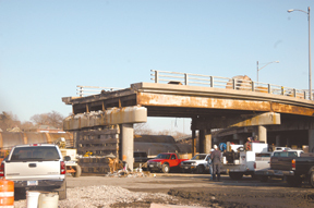
make way for future developments.
When the shadow of interstate concrete disappears from Providence River’s west
bank, tree-lined streets and quaint New England-style shops may appear, according
to state Department of Transportation projections.
The DOT is working with Providence officials and the Rhode Island Economic Development Corporation to figure out how to sell the 20 acres of land that will be vacant when Route 195 is relocated.
Under the I-195 Redevelopment Act of 2002, all planning and development of the land where Route 195 is has to be consistent with Providence’s Old Harbor Plan, which calls for a mix of residential and commercial uses. The nine-person I-195 redevelopment board – made up of DOT officials, economic development board members, Providence officials as well as private sector representatives – is supervising developments.
Building a Strong Data Foundation in the Age of AI
Artificial intelligence (AI) has become a key priority in the boardroom and across management —…
Learn More
The DOT owns 35 acres of land purchased through eminent domain and acquisitions to build I-195 in the 1950s. Some of the land will be used for parks and walks, leaving 20 acres of property valued at $40 million vacant for development.
“It’s desirable property because it’s right along the waterfront between downtown and the Jewelry District with easy highway access,” said DOT Chief Engineer Ed Parker.
Developers have expressed their interest in buying the land since “day one,” Parker said. He did not name any potential bidders, but Johnson & Wales University has been vocal in past years about wanting a piece of the property near its existing campus.
“The challenge now is the process of reassembling the parcels so it can be developed. At this point we are trying to answer questions about how the buying process will work, how the land will be zoned, who will pay for utilities, if one developer can handle it all or if we should sell to more than one.”
Boston residents and officials have been looking at the same type of land use scenarios stemming from the Big Dig.
“Figuring out what to do with the land has been a public process for eight years now. We’ve had 900 public meetings to hear the public’s concerns,” said Massachusetts Turnpike Authority spokesman Sean O’Neill.
Part of the Big Dig project in Boston was to put a portion of the downtown Interstate 93 highway underground, exposing 250 acres of land for open space and about 27 acres for real estate development, O’Neill said.
“We are trying to stitch the city back to its waterfront, very similar to what Providence is doing,” O’Neill said.
The Massachusetts Turnpike Authority included a “conservative estimate” of $90 million for the future sale of the “South Bay Interchange” property, which will offset the cost of the project, O’Neill said. The downtown Boston waterfront property is expected to go up for sale in 2006, a year after the Central Artery project is set for completion.
Though the Rhode Island DOT has visuals for what the land could become and it will benefit from the sale, which was included in their project budget to offset some of the costs, they are not influencing what is developed on the property, Parker said.
“We are leaving that up to the city,” Parker said.
The land is expected to be available for sale in 2011 or 2012 after the new I-195 is constructed and demolition of the existing I-195 is complete, according to Parker.
The land may or may not be in development condition at that time, but Rhode Island Economic Development Corporation spokesman Townsend Goddard said the EDC plans to do whatever it can to make sure the land is attractive to buyers