Almost every American city has had to live with at least one old highway overpass cutting through downtown that isolates neighborhoods and repels visitors.
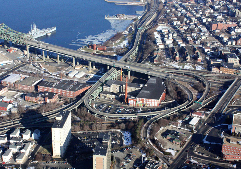
In Fall River the least popular is Route 79 and the tangle of ramps connecting it to Interstate 195 at the Braga Bridge. The rusted steel and concrete overpasses haven’t aged well and have been blamed for disconnecting the city from its waterfront.
Now Massachusetts is moving ahead with a long-awaited plan to replace the “spaghetti ramps” and the elevated Route 79 with a ground-level boulevard.
The $130 million project ties in with Fall River’s waterfront-redevelopment efforts and local leaders say it could help transform a large section of the city and draw activity to downtown.
“For us it is a game-changing event to bring those ramps down and create a boulevard along the waterfront,” said Robert Mellion, president of the Fall River Chamber of Commerce. “In 1965, the federal government diverted the business-district core from the waterfront and created a physical barrier that has been very difficult to overcome. It created an avenue to bypass Fall River and now we are going to have the opportunity to remedy this long-time wrong.”
In many ways, the Route 79 project shares similarities with other major highway projects like the Route 18 reconstruction on the New Bedford waterfront and the I-195 relocation in Providence.
All three were designed to replace deteriorating highways with new roadways that won’t sever downtown from waterfront neighborhoods.
“By taking this ramp system down to the ground, we are able to open up additional commercial acreage for development,” Mellion said. “Now you have a highway system that allows access on and off. It helps brings people into the city and increases opportunities to develop the waterfront commercially.”
The new push for mixed use has already seen the Quaker Mill redevelopment and the city is awaiting the opening of a branch of Jerry Remy’s Sports Bar and Grill this October.
Fall River Office of Economic Development Executive Vice President Kenneth Fiola Jr. said that in addition to direct economic-development opportunities, getting rid of the worst of the bridges and ramps would come with an aesthetic benefit.
“As you are traveling in and out of Fall River among bridge buttresses, ramps and decaying structures that don’t look safe, that reflects poorly on the image of the city,” Fiola said. “Removing the dilapidated bridge will help with curb appeal.”
The Route 79 project is part of Massachusetts’ $3 billion accelerated bridge program, which is funneling state and federal dollars toward reducing the backlog of 540 structurally deficient bridges in the state.
Realizing that the ramp complex, built in 1965, was becoming structurally unsound, the state began studying repairs and in 1999 determined that many of the elevated overpasses were not worth fixing.
The entire project area includes 111 separate spans, 8,700 feet of roadway and nine ramps.
The state plans to select a design-build team this fall and start construction in February of 2013. If all goes ahead, construction is expected to last until 2016.
Initial plans for the project would have eliminated an I-195 ramp to Milliken Boulevard, but local concerns that this would reduce traffic to downtown resulted in the inclusion of a new ramp there.
The upcoming project will not deal with that section of the highway, but would be consistent with such a project in the future.
Another thing the project will not address is the dream of unearthing the Quequechan River and restoring the waterfall that gave the city its name but has long been buried underneath the concrete of the interchange.
Unearthing the falls was part of a 2009 plan developed by Newport Collaborative Architects, now Northeast Collaborative Architects, to first free the falls and then use them to generate electricity in a new hydropower station.
Getting the river out of the culvert and restoring the falls would require putting Pocasset Street in a tunnel and acquiring private property, according to a Massachusetts transportation-department project description.
The cost of the work has prevented the river-restoration project from being included in the Route 79 project, but the current design does not prevent it from being pursued in the future.
Most New England cities, including Providence and New Bedford, are pursuing some form of waterfront redevelopment.
Unlike many cities that are hoping to rebuild an exclusively working waterfront, Fall River has opened up its waterfront to nearly all potential uses.
“What we are trying to do is adapt to the market demands,” Fiola said. “Rather than having the waterfront remain idle in the hope that water-dependent industries come back, we realized that we will probably derive more job opportunities by creating a mixed-use waterfront with greater public accessibility.” •